Details
-
Type:
 Bug
Bug
-
Status:
 Ready for QA
(View Workflow)
Ready for QA
(View Workflow)
-
Priority:
 Normal
-
Resolution: Unresolved
-
Affects Version/s: UA 4.0.0.2
-
Fix Version/s: UCMDB 4.0.0.23
-
Component/s: UCMDB
-
Labels:None Labels
-
Customer:Mobinets
-
Severity:Major
-
Classification:Req. Tuning
Description
Description:
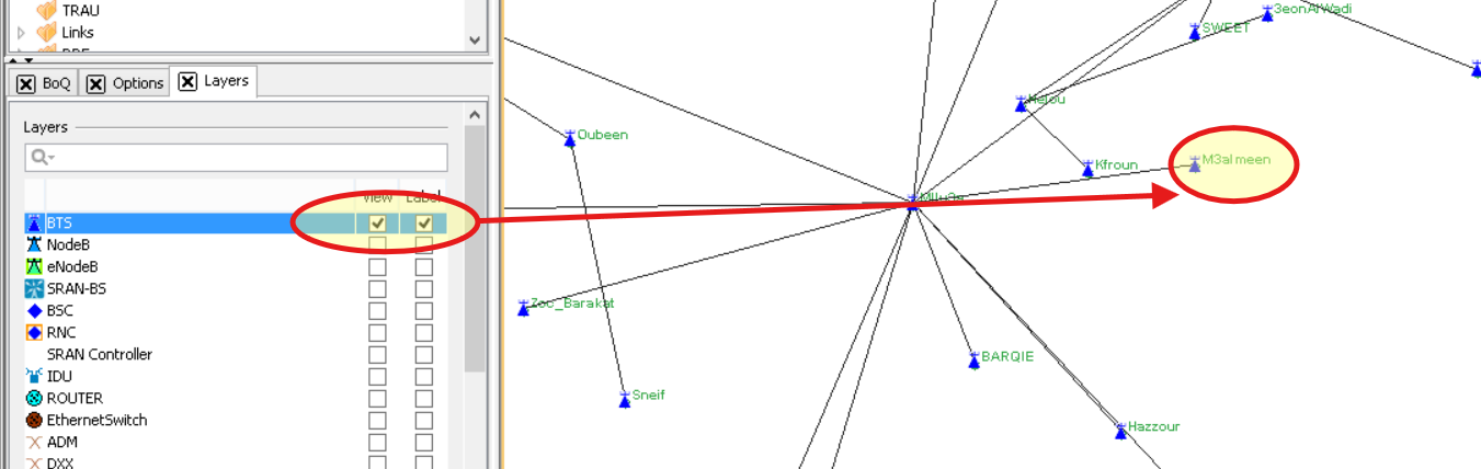
In the Swing implementation, users can display or hide labels per GIS layer. This capability is currently missing in the new web version and needs to be implemented.
Current Behavior:
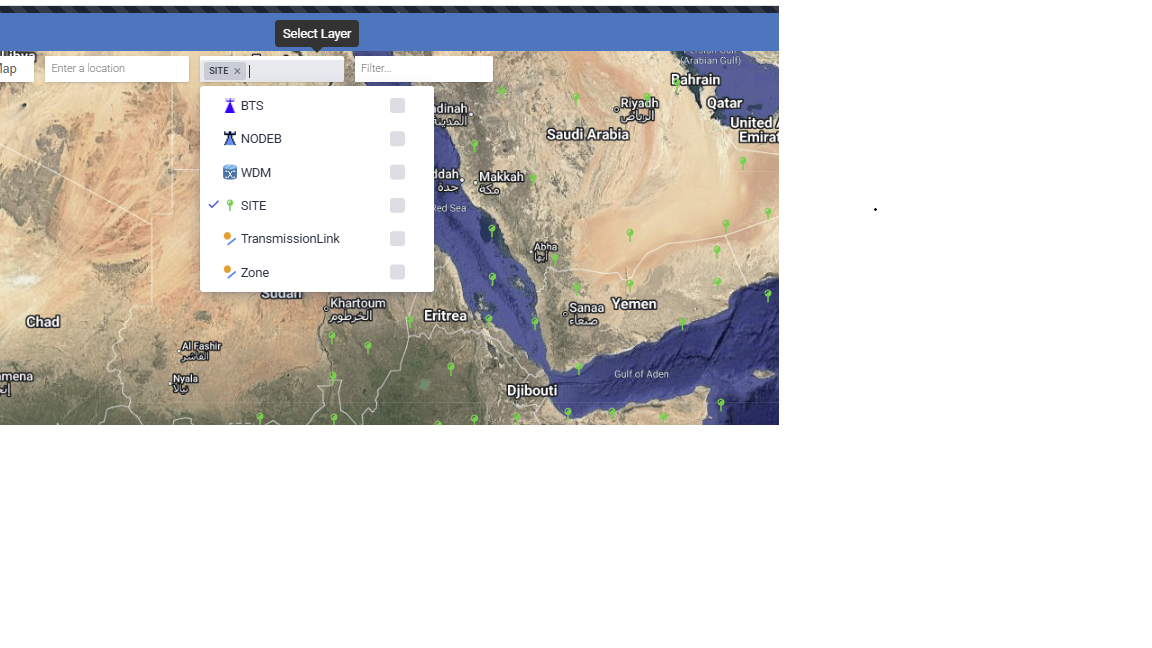
The new web version does not provide the ability to selectively show/hide labels on a per-layer basis like Swing does.
Required Changes:
Implement functionality that allows users to toggle label visibility for each GIS layer independently, matching the behavior available in the Swing implementation.
Attachments

Activity
| Field | Original Value | New Value |
|---|---|---|
| Gantt Options | Milestone (set to milestone: having a due date but zero effort) | |
| Planned Start | 2025-06-30 24:00 (milestone: set planned start date to due date) | |
| Planned End | 2025-06-30 24:00 (milestone: set planned end date to due date) |
| Attachment | Screenshot 2025-06-11 155706.png [ 110916 ] |
| Description |
*Description:*
In the Swing implementation, users can display or hide labels per GIS layer. This capability is currently missing in the new web version and needs to be implemented. *Current Behavior:* The new web version does not provide the ability to selectively show/hide labels on a per-layer basis like Swing does. *Required Changes:* Implement functionality that allows users to toggle label visibility for each GIS layer independently, matching the behavior available in the Swing implementation. |
*Description:*
In the Swing implementation, users can display or hide labels per GIS layer. This capability is currently missing in the new web version and needs to be implemented. *Current Behavior:* The new web version does not provide the ability to selectively show/hide labels on a per-layer basis like Swing does. *Required Changes:* Implement functionality that allows users to toggle label visibility for each GIS layer independently, matching the behavior available in the Swing implementation. !Screenshot 2025-06-11 155706.png! |
| Assignee | Hassan Abdine [ habdine ] | Khaled Khalil [ kkhalil ] |
| Assignee | Khaled Khalil [ kkhalil ] | Abdel Rahman Tout [ atout ] |
| Assignee | Abdel Rahman Tout [ atout ] | Bessem Manita [ bmanita ] |
| Assignee | Bessem Manita [ bmanita ] | Omar Kamalddine [ okamalddine ] |
| Assignee | Omar Kamalddine [ okamalddine ] | Khaled Khalil [ kkhalil ] |
| Assignee | Khaled Khalil [ kkhalil ] | Bessem Manita [ bmanita ] |
| Assignee | Bessem Manita [ bmanita ] | Zein Trabelsi [ ztrabelsi ] |
| Status | Open Bug [ 10108 ] | Dev Scheduled [ 10014 ] |
| Status | Dev Scheduled [ 10014 ] | Implementation in progress [ 10016 ] |
| Status | Implementation in progress [ 10016 ] | To Be Released [ 10400 ] |
| Attachment | Untitled.png [ 133903 ] |
| Status | To Be Released [ 10400 ] | Ready for QA [ 10023 ] |
| Assignee | Zein Trabelsi [ ztrabelsi ] | Hassan Abdine [ habdine ] |
| Reporter | Hassan Abdine [ habdine ] | Nemer Richmany [ nrichmany ] |
| Assignee | Hassan Abdine [ habdine ] | Nemer Richmany [ nrichmany ] |
| Fix Version/s | UCMDB 4.0.0.23 [ 48325 ] |
| Transition | Time In Source Status | Execution Times | Last Executer | Last Execution Date | |||||
|---|---|---|---|---|---|---|---|---|---|
|
326d 23h 14m | 1 | Zein Trabelsi | 04/May/26 11:33 AM | |||||
|
15s | 1 | Zein Trabelsi | 04/May/26 11:33 AM | |||||
|
59s | 1 | Zein Trabelsi | 04/May/26 11:34 AM | |||||
|
1m 9s | 1 | Khaled Khalil | 04/May/26 11:36 AM |

|
Links Hierarchy |
 Documentation Documentation
|
add per-layer label toggle checkbox in layer selection dropdown